Page Title:
West Point and the Hudson River Valley, the Key to the Continent|
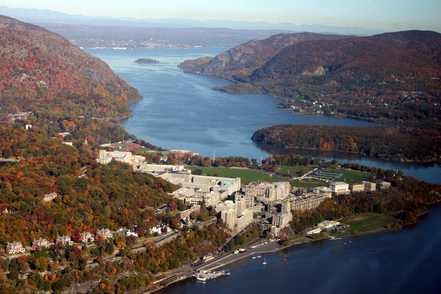
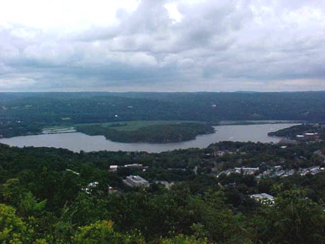
West Point looking north up the Hudson River towards Newburgh Bay Multiple Choice Question: Just why did the colonials establish a garrison at West Point? A) Because it is Federal property and therefore cheaper to camp there B) Because if you want to shoot at British ships and control the key to the continent you would rather NOT have to defend the river here: |
The Hudson River Valley, understood by both sides to be the "Key to the Continent" in the American Revolution. If the British could have controlled the Hudson River they could have used it to link up their forces in New York City with their forces in Canada. The Hudson River combined with lake George and Lake Champlain form a great big super highway that goes all the way to Montréal, the St. Lawrence River and the Atlantic ocean. Control it and you can move your troops north and south at will. You can supply and reinforce your forces from the Atlantic. You can support invasions to the interior. AND you can cut the colonies in two. You can separate New England from the Mid Atlantic colonies and The South. You can divide and conquer the American patriots by preventing them from helping each other. Colonial supplies and armies can not move. You can mop them up. Which brings us to that little public liberal arts college down the river from us: West Point |
|
|
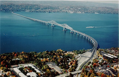
This is the Tappan Zee bridge. (Since this photo was taken
the bridge has been replaced by new one) Everyone around here has
driven it many times. Even as a kid I was fascinated by its curves and its length. The
car ride shore to shore is 3.1 miles!
Would you rather try to stop the most powerful navy in the world from coming up river here in Tappan Zee about 20 miles below West Point................................... |
|
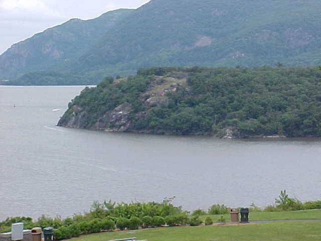
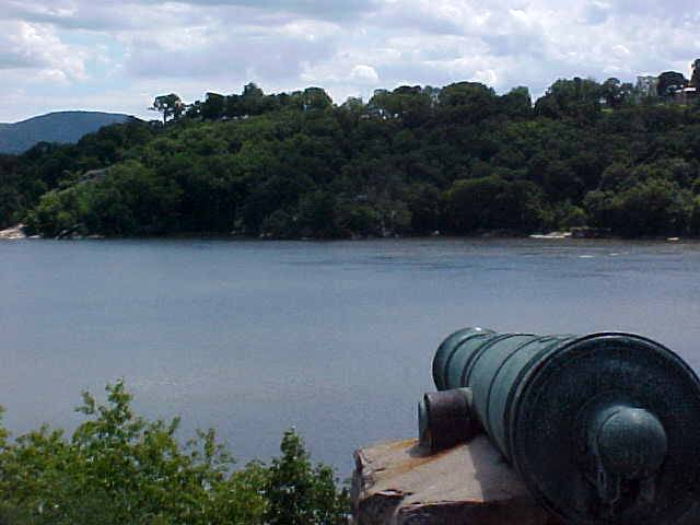
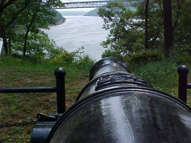
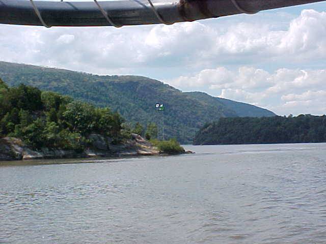
View from Trophy Point at West Point looking across the river at Constitution Island. There are still colonial fortifications to be seen on the island. Some are right there among the rocks in my photo. |
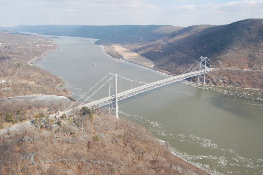
....or would you rather shoot at them from West Point? The Hudson River narrows to about 1,500' here.
OK General, you pick where to place your men. Tappan Zee, or West Point? |
|
|
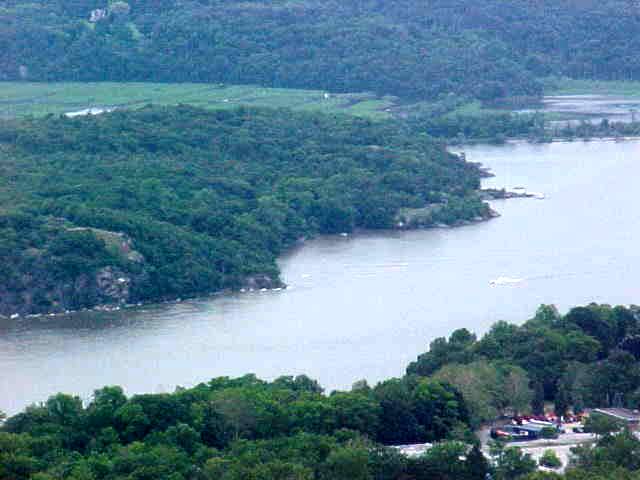
Here's another look at those same rocks on Constitution
Island where there are still colonial fortifications.
Again, a real nice narrow river. But wait, it gets better. Not only is the river narrow there. An invading fleet does not have a straight run past your shore batteries. Take another look at the first image on this page. Notice that little curve in the river. It is the strategic "S shape curve"
|
|
|
Here you go: The Key to the Continent. The Hudson River is
tidal at this point. Try bringing your sail powered war ship up the river on
just the wrong day, with just the wrong tide, and just the wrong wind and
you may not even be able to sail it around this curve. I saw historian and
former Superintendent of West Point, David Palmer, say in a documentary that
sometimes ships had to be towed through this curve using row boats! Ouch. This photo is looking down on to West Point from Rt. 9W. In this view you are standing on the west side of the river looking east. That is Constitution Island on the other side. If you make a trip here, this is a great drive to make. |
 |
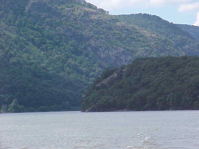
Here is what you see heading north up the river as you approach the left hand turn to enter the S-shape curve. The giant three mile wide river you had 20 miles earlier at Tappan Zee seems to disappear. The river looks like it dead ends. That is Constitution Island dead ahead. |
 |
But wait, there you go. The Hudson bends left and you are
about to enter the S-shape curve.
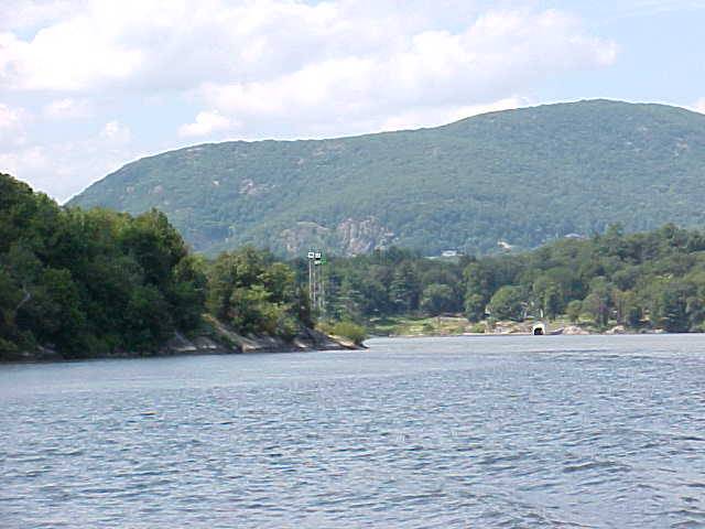
By the way, we call this whole place West Point. Indeed West Point is the United States Military Academy, and it is the whole army post. But the actual geographical feature that is named West Point is that rock jutting out into the river there on the left with the beacon mounted on it. On a river chart, that rock is West Point.
|
 |
Now you are smack in the middle of your trip through the
S-shape curve You can see the river about to bend right again there in the background as it continues north toward Newburgh. Careful! Colonial fortifications are built into the rocks there on Constitution Island. You better keep moving! |
|
|
The colonials had a garrison and batteries here on
Constitution Island. West Point is over there on the west bank. Again, where would you like to make your stand against the British Navy? Here or down river at Tappan Zee? But wait, it gets even better. How about we rig a big giant clumsy heavy chain across the river just to make it more difficult for an invasion fleet to pass. A what?! A Chain? |
|
|
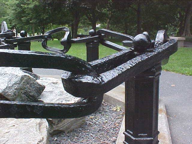
Yup. A chain. In, what for the time was a Herculean effort
and a marvel of technology and engineering, they dug iron ore out of the
Ramapo Mountains, made iron in blast furnaces, hauled it over the
mountains in winter and forged it into this massive chain in New Windsor.
They floated it down the river and installed it from West Point over to
Constitution island. It floated on rafts made from giant timbers and it
was protected by an additional log boom through which an attacking ship would have
to crash first before trying to break the chain. If you visit Washington's
HQ in Newburgh, you can see part of that boom in the
museum.
|
|
|
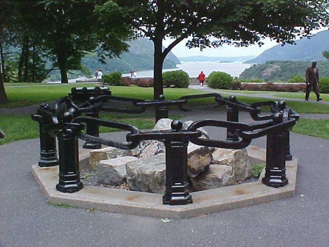
Today a symbolic 13 links of the West Point chain, "the
great chain", are on
display at Trophy Point. Each link weighs about 150 lbs. In the old days before 911 you could just go on
post and stroll around. Now you must take the official tour to get on post
and visit the
chain. This was actually the second chain and it was never tested by a British ship. But the British knew it was there.
|
|
|
The first chain was tried just a bit below West Point here
where you see the Bear Mountain Bridge. It was installed across the river
about right where you see the bridge today To protect the chain, two forts were built. Fort Clinton was about where you see the approach to the bridge on the left side. Notice the creek entering the river just above the bridge entrance. The second fort, Fort Montgomery is just on the other side of that gorge formed by the creek.
|
|
Colonial Welcome to British Troops. They would be coming up the river from New York City right under the guns of Fort Montgomery's main battery-It overlooks the position of the first Hudson River chain. |
On October 6, 1777 America was on the ropes. In an attempt to control the Hudson Valley, British, Loyalist and Hessian forces attacked the twin forts. About 600 patriots, many of them local lads, attempted to hold off about 1,800 attackers. They were driven from the forts by bayonet and suffered 50% losses in a desperate but failed attempt to hold their positions. They had refused a British offer to surrender the forts and spare themselves the attack. Fort Montgomery is a well interpreted state historic site. It is an amazing place to stand and contemplate the sacrifices made for us that October day so many years ago. |
|
This first chain fell. The British cut it and continued up
the Hudson River to Kingston, the then capital of NY State, which they
burned. The lower Hudson Valley was now in their control. But there was a problem. This British force was only one wave of a three pronged attack. All three waves needed to link up to control the Hudson River. A second force coming east through the Mohawk Valley upstate under Barry St. Leger was defeated by New Yorkers with attitude at the Battle of Oriskany and forced to retreat. Plus in what is often considered the turning point of the war, the third force coming down from Canada was defeated at Saratoga New York and forced to surrender. This was a huge deal. A professional mighty British army surrendered to what Europe had considered to be a bunch of no account ragamuffins. |
|
|
I once saw a list of the 100 battles most important in their influence on all of world history. Historians had been poled to create it. The Battle of Saratoga was on that list. The victory showed that the Continental Army and the American cause had legs. It gave the French the confidence they had been seeking that the American rebels were worth backing. Without French money, materiel, troops, ships and without French blood, the American cause would have had very little chance of success. The colonials had held the Hudson River Valley, the key to the continent, against a determined British invasion. The British force that had taken Fort Montgomery and Fort Clinton was left unsupported and withdrew back down the river never to return. The British still held New York City and Canada. They had failed to gain the Hudson and had failed to split the colonies. They did not try again to gain the Hudson by invasion. They did try in a more subtle way. Most people know that the name Benedict Arnold is synonymous with treason. Did you know that the traitorous act he undertook was an attempt to hand over West Point to the British while he was the commander there? Now that you can see the importance of West Point, its little S shape curve and the Hudson River Valley, you can even better appreciate what a significant act his treason was.
|
|
|
|
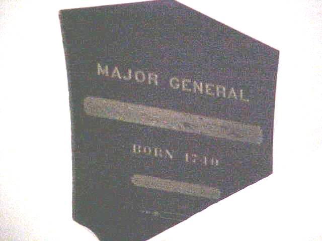
The Old Cadet Chapel at the West Point Cemetery has built
into its interior walls black marble tablets bearing the names, ranks
birth and death dates of Revolutionary War Generals. In recognition of the historical fact that Arnold Was a Revolutionary War general who served valiantly in the invasion of Canada and at the Battle of Saratoga, he has a tablet there. In recognition of his dastardly act, his name does not appear. His tablet bears only the words "Major General" and "Born 1740" |